SEPAL: Detecting Forest Change from Restoration Activities in Uganda
SEPAL: Detecting Forest Change from Restoration Activities in Uganda
The FAO and National Forest Authority (NFA) of Uganda used the System for Earth Observation Data Access, Processing, and Analysis for Land Monitoring (SEPAL) to monitor forest restoration activities in selected sites of Central Forest Reserves (CFRs) managed by NFA. FAO and NFA used SEPAL to develop a methodological approach that could be scaled to monitor restoration activities at a landscape level, with the overarching aim of reporting on forest changes and the area of forest gain resulting from the restoration activities implemented by the Ugandan government. These restoration activities included afforestation, reforestation, natural/assisted regeneration, and agroforestry. The methodological approach developed by FAO and NFA focused on using remote sensing techniques.
FAO and NFA chose to use SEPAL because it is a user-friendly and efficient tool for accessing and processing satellite imagery, including imagery from the Landsat and Sentinel-2 satellites and freely available Planet data through Norway's International Climate and Forests Initiative (NICFI) Satellite Data Program. They also chose SEPAL because of familiarity with the tool. The NFA and FAO team previously used SEPAL to map land cover and land cover changes in Uganda, the results of which were reported in Uganda’s Forest Reference Emission Level (FREL) and Biannual Update Reports (BUR) to the UNFCCC.
The NFA and FAO implemented the following steps to monitor restoration in the CFRs:
- Selection of the restoration sites: The sites were selected from a database of restoration activities carried out by NFA and each site had attribute information such as type of restoration, year of restoration, plant species, and forest area.
- Generation of time series images: Satellite image mosaics were produced for each site based on the site attribute information found in step 1.
- Running time series analysis using the BFAST (Breaks For Additive Season and Trend) tool. BFAST is a tool within the SEPAL platform used to analyze changes within a time series of satellite imagery.
- Visual interpretation using high-resolution images such as NICFI’s Planet data.
Steps 1-3 were carried out with SEPAL’s user-friendly interface and analysis tools. For example, in step 2, FAO and NFA used the Clip Time Series tool in SEPAL (see Figure 1) to create image mosaics with data from the Landsat and Sentinel-2 satellites. The Clip Time Series tool allows the user to create and download auto-generated time series for a date range over any specified coordinates or polygons.
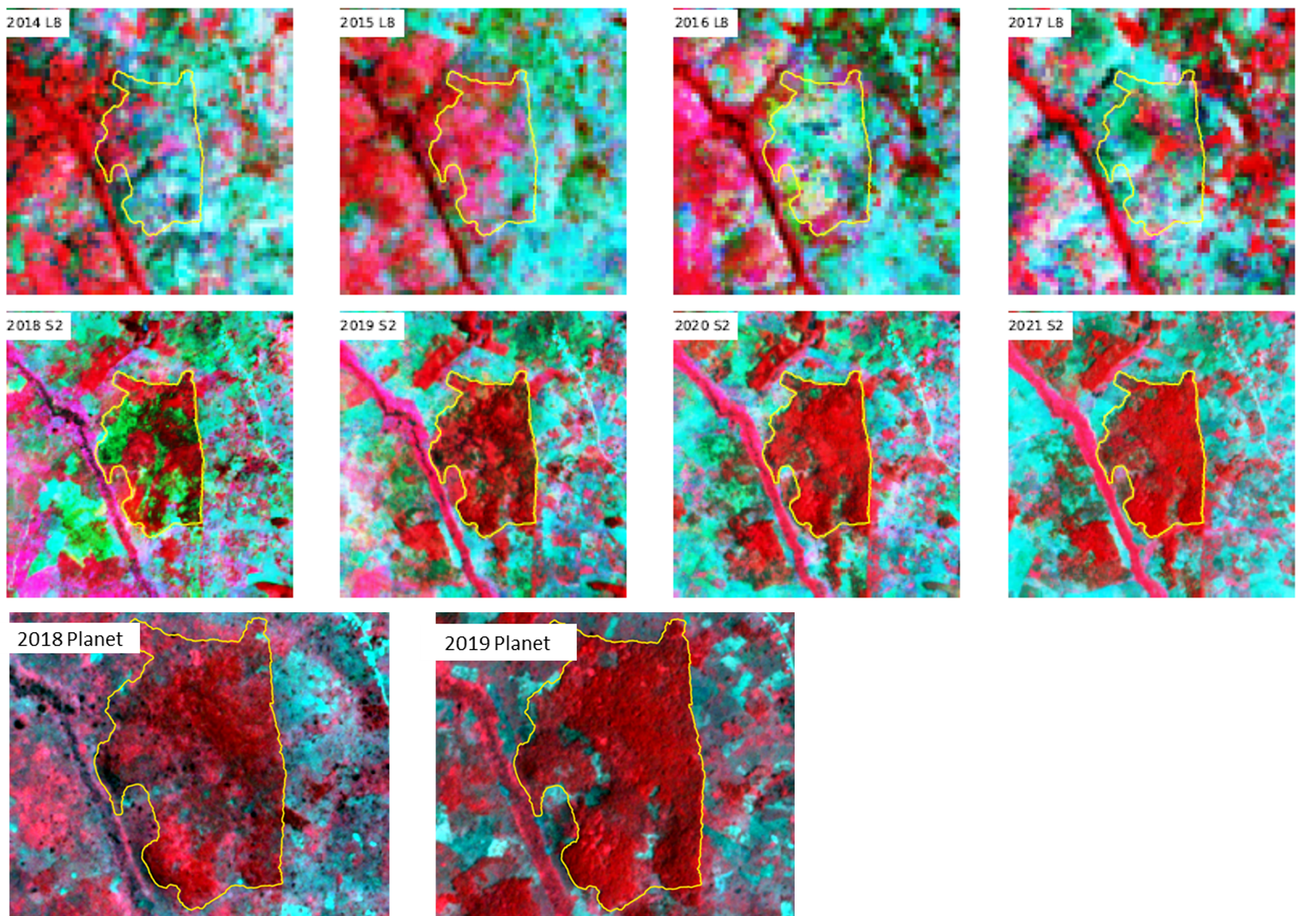
Figure 1. Satellite images mosaics showing Planet NICFI mosaics from 2015 to 2020 that are used for the visual interpretation of the forest restoration. Tree cover is shown in red in these false color images. The red area expands over time, indicating an increase in forest area.
Generation of the Clip Time Series was a crucial step for developing the restoration monitoring methodology in the CFRs because it helped FAO and NFA to identify the year in which vegetation change occurred in project sites. This “year of change” information was then used to determine the history and monitoring periods to consider while running BFAST to detect the forest gain for each site. The result from the BFAST analysis was a map of magnitude of change for each site. The magnitudes of change were then reclassified into change classes (see Figure 2). NFA uses these change class maps to assess the status of the restoration activities within the selected sites.
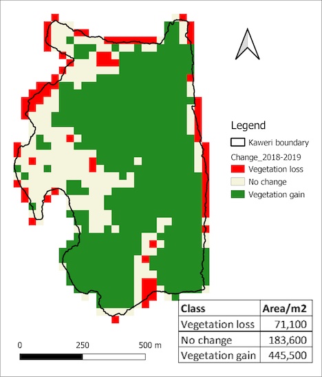
Figure 2. A map showing vegetation change detected in a period between 2018 and 2019 at 30-meter spatial resolution and estimated change area in Kaweri Central Forest Reserves of Uganda.
Based on the methodological process developed with FAO, NFA has integrated SEPAL into the national forest monitoring system. SEPAL’s user-friendly interface and extensive satellite imagery collection have enabled NFA to improve the timeliness and accuracy of forest monitoring.