SEPAL: Assessing Land Degradation in Bangladesh
SEPAL: Assessing Land Degradation in Bangladesh
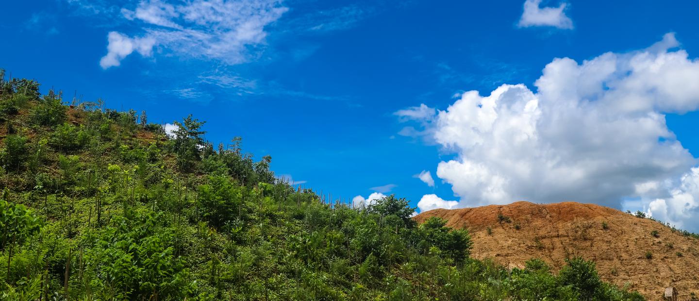
The influx of nearly one million Rohingya refugees and other forcibly displaced peoples from Myanmar since August 2017 has made Cox's Bazar – the southernmost coastal hill district of Bangladesh – home to one of the largest refugee camps in the world. The camp puts significant pressure on the regional landscape due to removal of trees, roots, and cover grass to provide shelter and fuel for this displaced population. A rapid remote sensing analysis found that about 7,220 hectares of forestland were degraded in the year following the influx of refugees in 2017 (see Figure 1).
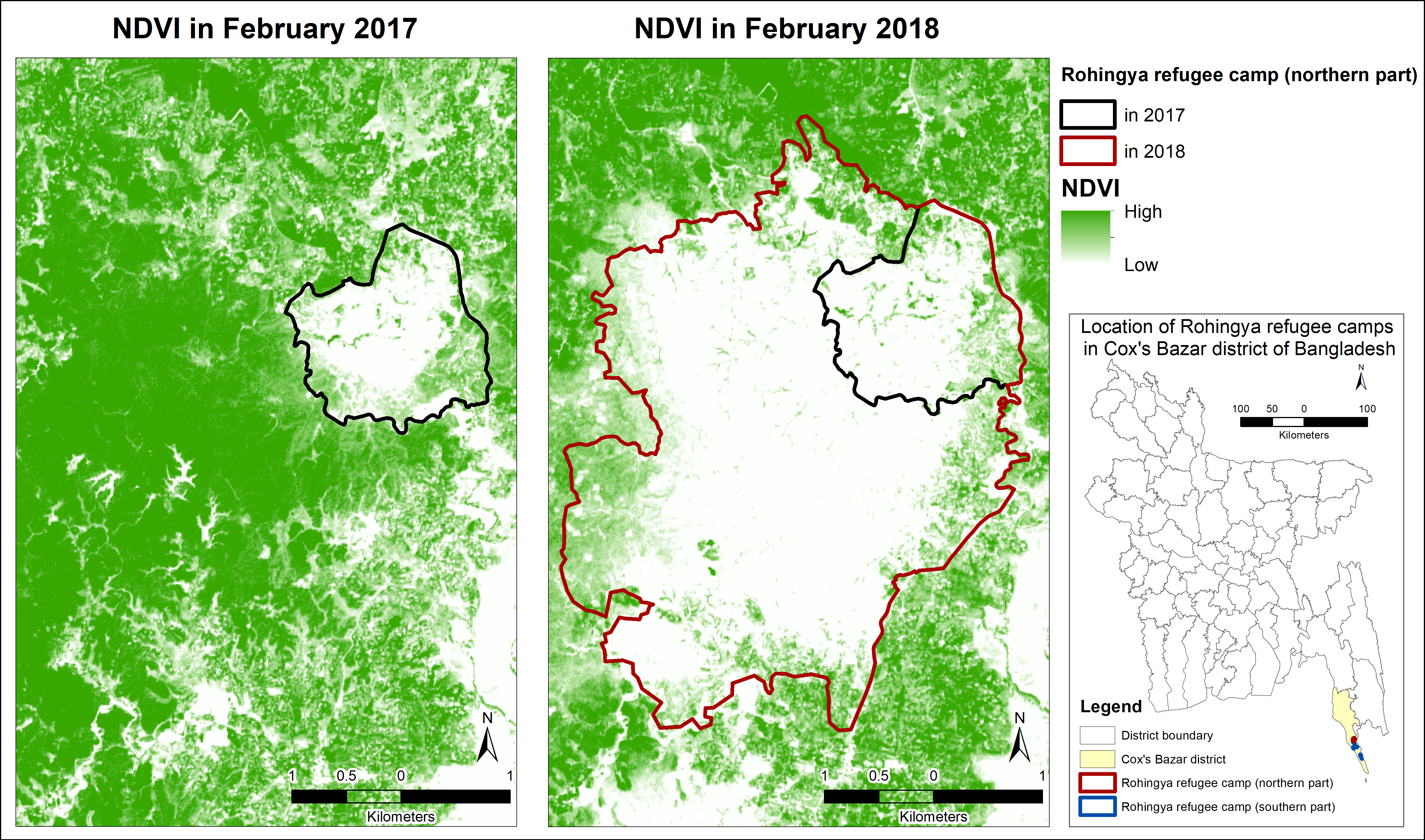
Figure 1. Change of vegetation between 2017 and 2018 as depicted by a decreased normalized difference vegetation index (NDVI). A lower NDVI means less vegetation cover.
In response to this degradation and the needs of the camp residents, since 2018, the FAO has been collaborating with the Bangladesh Forest Department (BFD), national and international agencies coordinated by the Cox’s Bazar Energy and Environment Technical Working Group (EETWG), and, most importantly, the local host communities and Rohingya refugees, to implement an integrated land restoration approach to rehabilitate the degraded forestlands inside and outside the camp area. FAO and BFD are working with collaborators in 600 hectares in and around the refugee camp to implement restoration activities. These activities include riparian plantation, roadside plantation, land stabilization, afforestation/reforestation, and forest restoration.
FAO and its collaborators are using the System for Earth Observation Data Access, Processing, and Analysis for Land Monitoring (SEPAL) to monitor these restoration efforts. Specifically, they used the SEPAL platform’s module for the Sustainable Development Goal (SDG) indicator 15.3.1, which measures the “proportion of land that is degraded over total land area," based on UNCCD’s Good Practice Guidance version 2 for the indicator. The extent of land degradation is measured based on trends in land cover, land productivity, and carbon stocks. These three indicators are combined to measure land degradation and assess the effectiveness of restoration initiatives in Cox’s Bazar.
FAO and the BFD selected the SEPAL SDG indicator 15.3.1 module because it is simple to use, it is customizable, and it facilitates combining ground-level and satellite data to monitor over time and across scales. Local collaborators require only a web browser and internet connection to input data and generate results. The input data are customizable such that data from multiple satellite sensors are available, allowing users to derive more accurate time series data on vegetation cover. Finally, the option to combine locally-collected data with up-to-date advanced earth observation and geospatial analyses is essential for identifying early trends in land degradation and the impacts of restoration initiatives and to consistently measure changes in land cover at Cox’s Bazar over time. Early identification and consistent monitoring help implementers to know if restoration initiatives are working and to adapt approaches where needed.
Per the UNCCD good practice guidance for the SEPAL SDG indicator 15.3.1 module, productivity was assessed using three metrics: trend, state, and performance. The “trend” metric measures the trajectory of productivity change over the long term; the “state” metric compares the current productivity in the area of interest to historical observations in the same area; and the “performance” metric assesses the level of local productivity compared with other areas with a similar productivity potential in the region. Results for each of these metrics are then combined into the final “land productivity” sub-indicator, with categories of degradation, stable, and improvement.
The maps in Figure 2 depict how the SEPAL module was used to perform a comparative assessment of degradation and improvement in the restoration areas within Cox’s Bazar for the baseline and monitoring periods of 2000 to 2015 and 2016 to 2019, respectively. The analysis found an overall pattern of more degradation than improvement in the monitored area in both time periods, which is likely due to the short timespan between when restoration interventions were implemented and when the productivity analysis was conducted. Future analyses, after more time has passed, will be conducted to account for the lag-time between when implementation occurred and when changes can be detected.
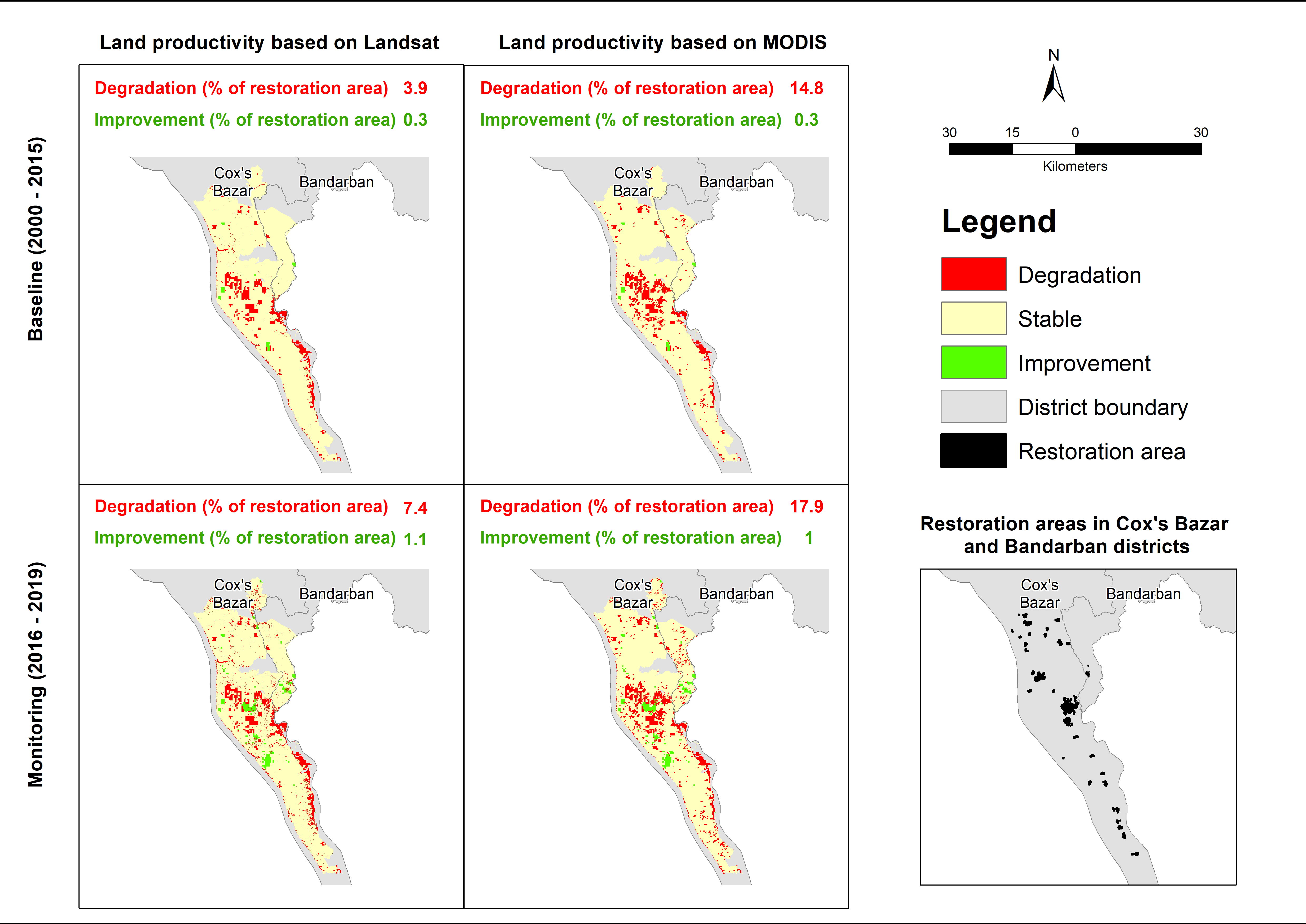
Figure 2. Degradation and improvement in baseline and monitoring period in the restoration areas in Cox’s Bazar and Bandarban districts, Bangladesh using the SEPAL SDG indicator 15.3.1 module based on MODIS and Landsat.
While the interface of the SEPAL module is simple and intuitive, proper interpretation of the results and understanding of the methodology are necessary to assess the effectiveness of restoration initiatives. To enhance the capacity of collaborators, FAO conducted a national-level technical training on the use of the module as a part of a series of trainings to strengthen capacities and improve the organizational data management policy of relevant government agencies in Bangladesh. The results for Cox’s Bazar were shared with the EETWG in December 2021 and follow-up workshops and trainings are planned to incorporate the application of the module for improved restoration monitoring in Cox’s Bazar. Once incorporated, the results are expected to be used to identify the locations where the restoration efforts have succeeded or failed. The influencing factors for both success and failure will be identified from field investigation. These lessons learned will facilitate the next steps for ensuring good management and sustainability of restoration initiatives.
Read the full study here: Jalal, R.; Mahamud, R.; Arif, M.T.A.; Ritu, S.; Kumar, M.F.; Ahmed, B.; Kabir, M.H.; Rana, M.S.; Huda, H.N.; DeGaetano, M.; Agnew, P.J.; Ghosh, A.; Mushtaq, F.; Martín-Ortega, P.; Vollrath, A.; Finegold, Y.; Franceschini, G.; d’Annunzio, R.; Jonckheere, I.; Henry, M. Restoring Degraded Landscapes through an Integrated Approach Using Geospatial Technologies in the Context of the Humanitarian Crisis in Cox’s Bazar, Bangladesh. Land 2023, 12, 352. https://doi.org/10.3390/land12020352